French
Vidéo: Libérer le potentiel des forêts communautaires en RDC
Aujourd’hui, la Rainforest Foundation UK (RFUK) a sorti un court film à propos de son projet concernant les forêts communautaires en République démocratique du Congo (RDC). Le film met en scène plusieurs communautés au moment où elles obtiennent des droits juridiques sur leurs forêts et sont officiellement reconnues comme les gestionnaires de leur environnement local. … Read more

Participatory Mapping and Community Forests in the Democratic Republic of Congo
If well implemented, new community forest legislation in the DRC offers an unprecedented opportunity for communities to obtain legal rights to forests they have inhabited for generations and to improve their livelihoods. However, for community forests to deliver equitable and sustainable outcomes there is a need to ensure that they are developed by the communities themselves, … Read more

Securing forests from the bottom up: How participatory maps can support community forests in the Congo Basin
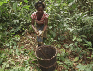
Members of Ilinga community, in DRC’s Equateur Province, celebrate as their community forest is officially granted in September 2018. Ilinga is one of several communities supported by the Rainforest Foundation UK and its local partners to map their forests and obtain a community forest. For years, there has been a growing consensus that securing land … Read more
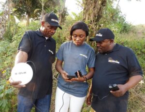
RFUK’s Real-time Monitoring project expands to new communities in Africa
RFUK’s ForestLink system is active in three countries in Africa and will soon expand to four. From left to right: Ghana, Cameroon, Republic of Congo, Democratic Republic of Congo. Upwards of 100 communities across Africa will benefit from the Rainforest Foundation UK’s Real-time Monitoring (RTM) project, thanks to new support from the UK Department for … Read more
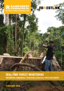
Real-time Forest Monitoring: Empowering Communities, Preventing Illegalities, Protecting Forests
Since its creation, ForestLink has been successfully deployed as part of RFUK’s Real-Time Forest Monitoring (RTM) initiative in Cameroon, the Democratic Republic of Congo (DRC), Ghana and Peru. By engaging forest and indigenous peoples in the fight against illegal logging and deforestation, RTM seeks to strengthen local involvement in forest management.
People, parks and social justice: How community maps can help make conservation better
By Maud Salber, Policy Advisor, RFUK The Tumba Lediima Reserve in the Democratic Republic of Congo (DRC) was established in 2006, mainly to protect the local population of bonobos. Remarkably, when Tumba Lediima’s borders were drawn, nobody had thought it worthwhile to properly documenting who was already living there, and how these people would be … Read more
Protected Areas and Community Rights: Using Local Maps to Support Sustainable Conservation in the Congo Basin
The best conservation projects start with people. Yet protected areas in the Congo Basin continue to be established and managed with poor consideration for local communities’ land and resource rights, fostering conflicts and human rights abuses. A lot of these toxic situations could be avoided if thorough participatory community mapping data, such as collected through MappingForRights, … Read more

ForestLink app helps catch illegal miners red-handed in Peru
Environmental police seized an estimated £1 million of illegal mining equipment during a raid near Barranco Chico, in Madre de Dios | Photo credit: FENAMAD Over the last two months, dozens of suspected illegal gold miners causing terrible environmental damage in the Peruvian Amazon were caught with the help of the ForestLink smartphone app developed by the Rainforest … Read more

Cameroon communities speak out about impacts of large rubber plantation
Representatives of 21 villages affected by industrial rubber project Sud-Cameroun Hevea (“Sudcam”), which is responsible for the largest single destruction of rainforests anywhere in Central Africa, have denounced the impacts of the rubber plantations on their rights and livelihoods. In a statement issued last week, they ask the Cameroonian government and the company that their rights are … Read more
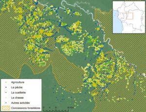
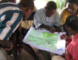
La cartographie communautaire peut permettre de contrer une des plus grandes menaces pesant sur le bassin du Congo
La planification participative de l’utilisation des terres, illustrée ici, peut aider les gouvernements à prendre des décisions éclairées concernant le régime foncier et la gestion des ressources naturelles. Les forêts tropicales de la République démocratique du Congo (RDC) sont parmi les plus intactes de la planète, avec des taux de déforestation beaucoup moins élevés qu’en … Read more